Iteris, Inc.
Iteris, Inc. (NASDAQ: ITI) is the global leader in applied informatics for transportation and agriculture, turning big data into big breakthrough solutions. We collect, aggregate and analyze data on traffic, roads, weather, water, soil and crops to generate precise informatics that lead to safer transportation and smarter farming. Municipalities, government agencies, crop science companies, farmers and agronomists around the world use our solutions to make roads safer and travel more efficient, as well as farmlands more sustainable, healthy and productive. Visit www.iteris.com for more information.
Information Technology and Services
200 - 500
Santa Ana, CA, United States
About

Iteris, Inc. (NASDAQ: ITI) is the global leader in applied informatics for transportation and agriculture, turning big data into big breakthrough solutions. We collect, aggregate and analyze data on traffic, roads, weather, water, soil and crops to generate precise informatics that lead to safer transportation and smarter farming. Municipalities, government agencies, crop science companies, farmers and agronomists around the world use our solutions to make roads safer and travel more efficient, as well as farmlands more sustainable, healthy and productive. Visit www.iteris.com for more information.

Site Traffic
  • 820700 Global Rank
  • 155362
    United States
Traffic Sources
  • Direct
    76.93%
  • Search
    17.47%
  • Referrals
    4.61%
  • Social
    0.99%
  • Display
    0.00%
  • Mail
    0.00%
Powered by
Alexa Traffic Data
Global Rank 318,465
1,864,962
United States Rank 151,314
45
United States Page Views 20.9%
7.5%
Top Countries
Top Search Keywords
  • Opportunities
  • Partners Programs
  • Amazon Associates Program
Mobile App Data
MixRank is the most comprehensive database of mobile apps, developers, SDKs, technologies, services, and integrations. Learn more.
  • 73 SDKs
  • 3.59 Avg. Rating
  • 181 Total reviews
  • App Url: https://itunes.apple.com/app/iteris-inc-/id520177066
  • App Support: http://www.virginiadot.org/travel/511_virginia_faqs.asp
  • Genre: Travel
  • Bundle ID: com.iteris.vdot
  • App Size: 72.4 M
  • Version: 4.0.17
  • Release Date: April 25th, 2012
  • Update Date: February 13th, 2018

Description:

The Virginia 511 mobile application combines official information from the Virginia Department of Transportation (VDOT), driving and transit directions from Google, navigation with Waze, and other sources of information to provide a dynamic one-stop-shop for traveler information needs across Virginia.

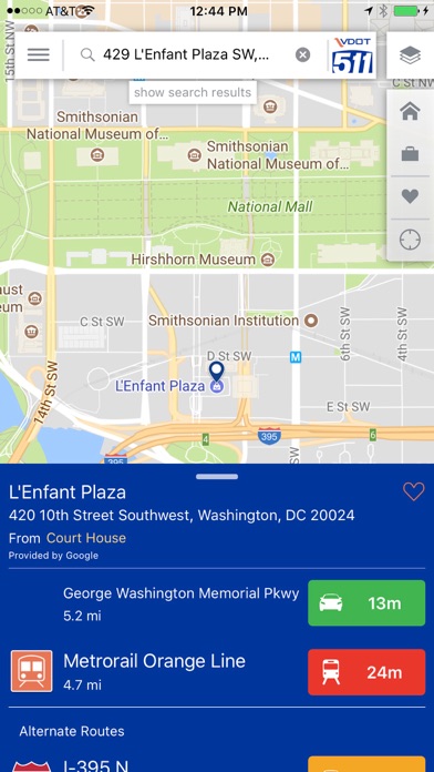
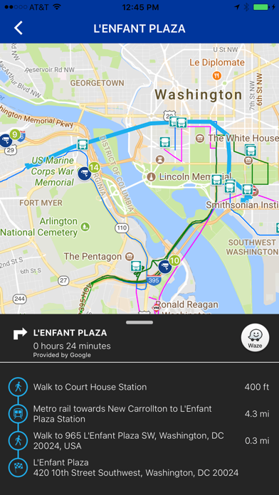
Open the app, search for any location in the search bar, and see travel times for driving and/or transit options to that location provided by Google. Tap on an option to see detailed driving or transit directions, then tap on the Waze button to open the Waze App for navigation to your destination (installation of Waze app is required to use this feature).

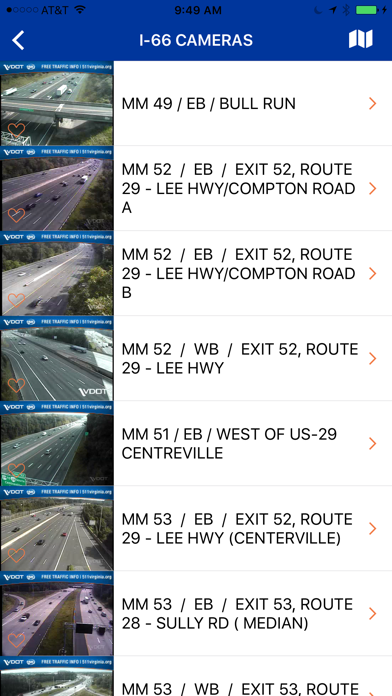
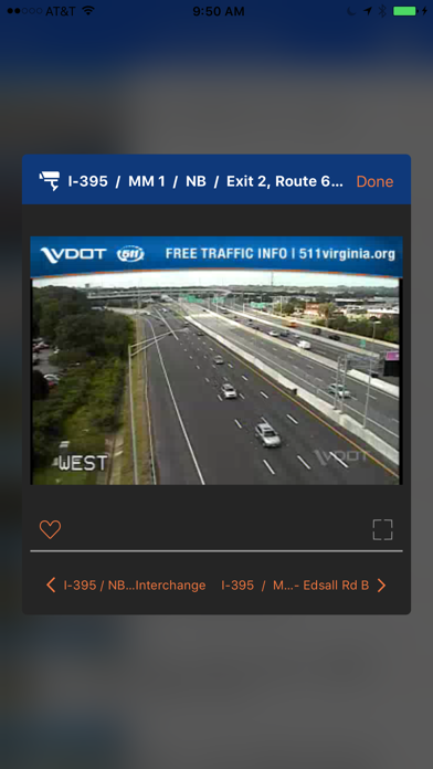
Access to VDOT cameras, incident reports, construction, bridge openings, and more is provided on the map by toggle option from the overlays menu in the upper right. Tap the pencil in this menu to re-order the Map Layers in the menu as you desire.

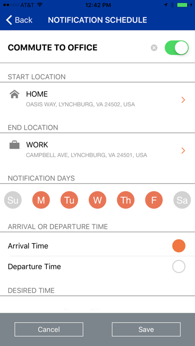
The main menu in the upper left provides access to Twitter feeds, cameras by route, travel times for predefined road segments, links to other commuter services for your area, and more. Settings can be accessed at the bottom of the main menu, and includes an option to sign up for trip notifications. Trip notifications allow you to define a recurring trip and desired arrival time, and receive a push notification in advance of the necessary departure time based upon the current traffic each day. Please note that traffic conditions can change rapidly, and travel and arrival times are a best estimate, but can never be a guarantee.

Additional information available in Northern Virginia includes VRE rail and PRTC bus schedules and routes, along with real-time VRE train locations. A unique feature provides a limited ability to see drive-to-transit options for these services when the “Nearby Transit Options” is selected from certain directions results. These services will be expanded in the future to include more agencies statewide. Other features in the app will also continue to be enhanced over time.

Daily Downloads Jun 01 - 30, 2024

Sort by

FFDR06

Jul 09, 2017

IOS/camera crash

Needs update for IPhone 7and IOS 10 support. When trying to go to cameras makes app crash. Still crashing!

Flossy0998

May 27, 2017

Awful

AWFUL : /

rnadyb

May 21, 2017

Favorite Cameras causing App to Crash

Cameras no longer loading.

Its Kooby

May 12, 2017

It's a mobile traffic app

I read some negative reviews and scoffed. I find the app excellent and informative with realtime updates. It includes access to all highway cameras that you can favorite for quick reference later. Yes the zoom levels could be better but it remains more than functional in its current state. The app also includes all twitter messages from VDOT so you don't actually have to follow to get them.

GreeneShirt

Mar 24, 2017

Absolutely terrible

You literally can't zoom in on what you are trying to look at without it snapping to some random mile marker 10 miles away.

sidc3000

Jan 15, 2017

SLOOOOOW

Ever since the previous update adding more roads, the app has been ridiculously slow loading. Almost unusable!
TwitterCore
Accelerate Framework
This document describes the Accelerate framework, which contains C APIs for vector and matrix math, digital signal processing, large number handling, and image processing.
Alamofire
AlamofireImage
Core Audio
Core Audio is the digital audio infrastructure of iOS and OS X. It includes a set of software frameworks designed to handle the audio needs in your applications. Read this chapter to learn what you can do with Core Audio.
Crashlytics
The most powerful, yet lightest weight crash reporting solution for iOS and Android developers. | Crashlytics
Fabric
A full suite of services created by the team that brought you Crashlytics. Fabric provides monetization, engagement and other uses for developers beyond crash reporting.
GLKit
The GLKit framework provides functions and classes that reduce the effort required to create new shader-based apps or to port existing apps that rely on fixed-function vertex or fragment processing provided by earlier versions of OpenGL ES or OpenGL.
Google Maps
With the Google Maps SDK for iOS, you can add maps based on Google maps data to your application. The SDK automatically handles access to the Google Maps servers, map display, and response to user gestures such as clicks and drags. You can also add markers, polylines, ground overlays and info windows to your map. These objects provide additional information for map locations, and allow user interaction with the map.
GooglePlaces
Google Places allows users to add up-to-date information about millions of locations to your iOS App.
Image IO Framework
The Image I/O programming interface framework allows applications to read and write most image file formats. This framework offers high efficiency, color management, and access to image metadata.
KeychainSwift
Data sourced from MixRank, the most comprehensive database of mobile apps, developers, SDKs, technologies, services, and integrations. Learn More.
Ad Intelligence
  • Standard
    100.00%
Ads Seen Recently
1
Longest Running Ad
Iteris, Inc.
Device
Desktop
Dimensions
728x90
Iteris, Inc.
Device
Desktop
Dimensions
728x90
Iteris, Inc. receives up to 0.03M pageviews per day.

They are headquartered at Santa Ana, CA, United States, and have 2 advertising & marketing contacts listed on Kochava. Iteris, Inc. works with Advertising technology companies such as DoubleClick.Net, Google Adsense, LinkedIn Ads, FLoC Opt-Out, FLoC.